SEIR:
- 1. Region that took its name from Seir the Horite, whose descendants occupied it, followed by Edom and his descendants. The earliest reference to the name is found in the Harris Egyptian papyrus, in which Rameses III. says (c. 1200 B.C.) that he gained a victory over the "Sa-'a-ira" (="Se'irim"), one of the Bedouin tribes of the desert. A distinction was at that time made between them and the Edomites. It has not been definitely decided whether the Seirites are identical with the Sheri mentioned in one of the Tell el-Amarna tablets. The Old Testament makes no distinction between them and the Edomites. According to the Old Testament, the Horites occupied the country before the Edomites (Gen. xiv. 6, xxxvi. 20; Deut. ii. 12, 22). These statements do not contradict the Egyptian account, since the word "Horite" (="cave-dweller") is not the name of a certain tribe, but may be a designation for the Seirites. The Edomites probably conquered the country after 1200 B.C. The Old Testament mentions most frequently the "mountains" of Seir (Gen. xxxvi. 8 et seq.; Deut. i. 2, ii. 1, et passim).But the phrase "land of Seir" also occurs (Gen. xxxii. 3, xxxvi. 30), as well as "sons of Seir" (II Chron. xxv. 11, 14; Gen. xxxvi. 20 et seq.), the latter referring both to the original inhabitants, the Horites, and to the Edomite population. The name of Seir, when used alone, designates either the land of Seir (Gen. xxxiii. 14 et passim) or the inhabitants (Ezek. xxv. 8). This district, the mountains of Seir, is Esau's home (Gen. xxxvi. 8), assigned to him and his descendants by Yhwh (Deut. ii. 5). Its location is given in Deut. ii. 1. The people of Israel skirted the mountains of Seir on the south so as not to enter Edomite territory; then they followed the eastern edge northward to the steppe of Moab. Hence the mountains of Seir lay on the east side of the Araba, that is, the dip extending from the Dead Sea southward to the northern point of the Gulf of Akaba, (see Palestine; comp. Gen. xiv. 6). Mountains rise on both sides of the dip, those on the east being considerably higher than those on the west. On the north the mountains end in the deep cut of the Wadi al-Aḥsa; and on the south a steep slope of the mountains forms a natural boundary toward Moab, while on the east the hills slope down toward the Syrian desert.The country of Seir is only about 15 or 20 miles wide, and is now called Jabal al-Shara. It is traversed by several valleys running east and west to the Araba. The mountain-tops are now bare, but the ancient name is generally interpreted to mean "a wooded region." The country is described as fertile: the information regarding it is still insufficient, being confined to the accounts of a few travelers. Although the name of Seir was originally that of this mountain country, it was gradually used in a wider sense, as designating the land of Edom; but the territory of Edom included the mountain country west of the Araba. The name is used in this wider sense in, for example, Judges v. 4, Deut. xxxiii. 2, and Josh. xi. 17. See Edom.Bibliography: Buhl, Gesch. der Edomiter, Leipsic, 1893.
- 2. Mountain, or mountain range, in Judah, between Kirjath-jearim and Chesalon, on the frontier of Benjamin; therefore, perhaps, the high ridge on which the village of Saris is now situated.
E. G. H. I. Be.Seixas Pedigree.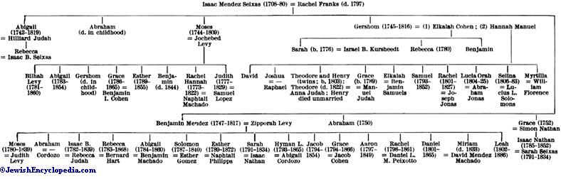 J.F. T. H.